Coal Creek Falls Cougar Mountain Hike near Seattle (car free option)
Last Updated on February 7, 2026
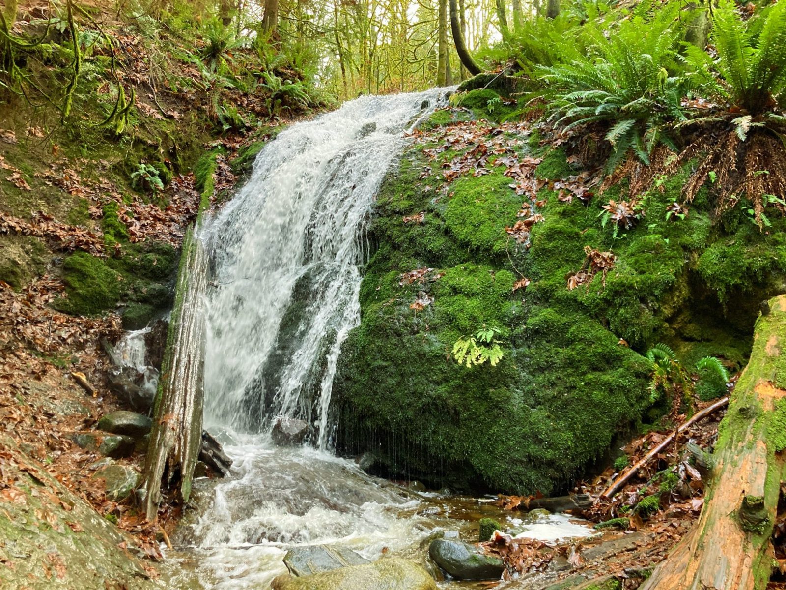
Coal Creek Falls in Cougar Mountain Regional Wildland Park is an ideal winter hike near Seattle and one of the best hikes in Bellevue. You can also get there by bus when the trailhead direct bus is operating (generally April through October). Coal Creek Falls makes a lovely 3 mile loop hike with 400 feet of elevation gain from the Red town Trailhead. If you’re taking the bus, you’ll be starting from the Sky Country Trailhead, which is a 2 mile round trip out and back hike with 300 feet of elevation gain. There is also a larger parking lot at the Sky Country Trailhead. You can make a larger loop of six miles with about 500 feet of elevation gain which is also described below.
- Jump to the 3 mile Coal Creek Falls Loop from the Red Town Trailhead
- Jump to the 2 mile Coal Creek Falls out and back from the Sky Country Trailhead
- Jump to the 6 mile round trip hike including Coal Creek Falls from the Sky Country Trailhead.
However you like it, Coal Creek Falls is a beautiful hike through the forest in any weather. I especially like this hike in the winter and spring when there’s the most water in the Falls.
Cougar Mountain Regional Wildland Park is the homeland of the Duwamish, Snoqualmie, Muckleshoot and other Coast Salish people.
Parking Pass: None
Dog Friendly: yes, on leash
Related: What to wear for a day hike in the Pacific Northwest, What to pack for a day hike in the Pacific Northwest
Is the Coal Creek Falls Hike right for me?
If you want a hike through the forest that’s close to town and in good condition with lots of options for different trails to follow, or you don’t have a car or don’t want to drive and deal with parking, then this hike is for you!
It’s also a good year round hiking option if you’re driving but don’t want to drive far. If you’re looking for a hike in the same area with more elevation gain, you could try the Wilderness Peak Loop Trail or Margaret’s Way (both can be accessed from the Margaret’s Way trailhead bus stop) or the Licorice Fern Trail.
When is a good time for Coal Creek Falls?
If you want to do this hike without a car, you’ll need to do it when the Trailhead Direct bus is operating, generally late April through October.
The hike itself can be done year round! Be aware that Coal Creek Falls might be dry or mostly dry in mid to late summer (unless it’s been rainy). I have run into some mosquitoes here in summer so be ready for that. This is a good winter hike and is generally snow free (though like all our trails, it gets muddy in winter!).
For me, this hike is ideal from December through May.
How do I get there?
By Public Transit-Car free
If you’re taking the bus (do it! it’s awesome), you’ll take the Trailhead Direct bus from Tukwila International Boulevard station (this is a stop on the light rail). The bus leaves approximately every 30 minutes in the morning and early afternoon (make sure to check metro’s website for the exact schedule). You can use your ORCA card to pay the fare, and if you don’t have one, you can pay with cash. The bus stops at the Renton Transit Center and in the Renton Highlands before arriving at the Sky Country Trailhead in about 40 minutes. The bus stop is right at the trailhead, super convenient!
By Car
You can start at either the Sky Country Trailhead or the Red Mountain Trailhead.
To get to the Red Mountain Trailhead, from I-405 in Bellevue, take Coal Creek Parkway. Then turn left on Forest Drive and right on Lakemont Blvd. The trailhead is marked and on the left in the middle of a sharp right turn.
To get to the Sky Country Trailhead, take Lakemont Boulevard and then left at the light on Cougar Mountain Way. Turn right on 166th which will take you straight to the trailhead.
Three Mile Coal Creek Falls Loop from Red Town Trailhead
This delightful three mile loop has 400 feet of elevation gain on a well maintained trail. Watch out for rocks in some places as well as mud. I like to wear rubber boots!
Starting from the Red Town Trailhead, take the wide gravel trail going uphill on the Red Town Trail. In about a quarter mile you’ll come to a junction with the Cave Hole trail, turn left here. In a very short distance at the next junction, turn right to stay on the Cave Hole Trail. The trail stays wide and graveled, although there are a few more rocks on this section.
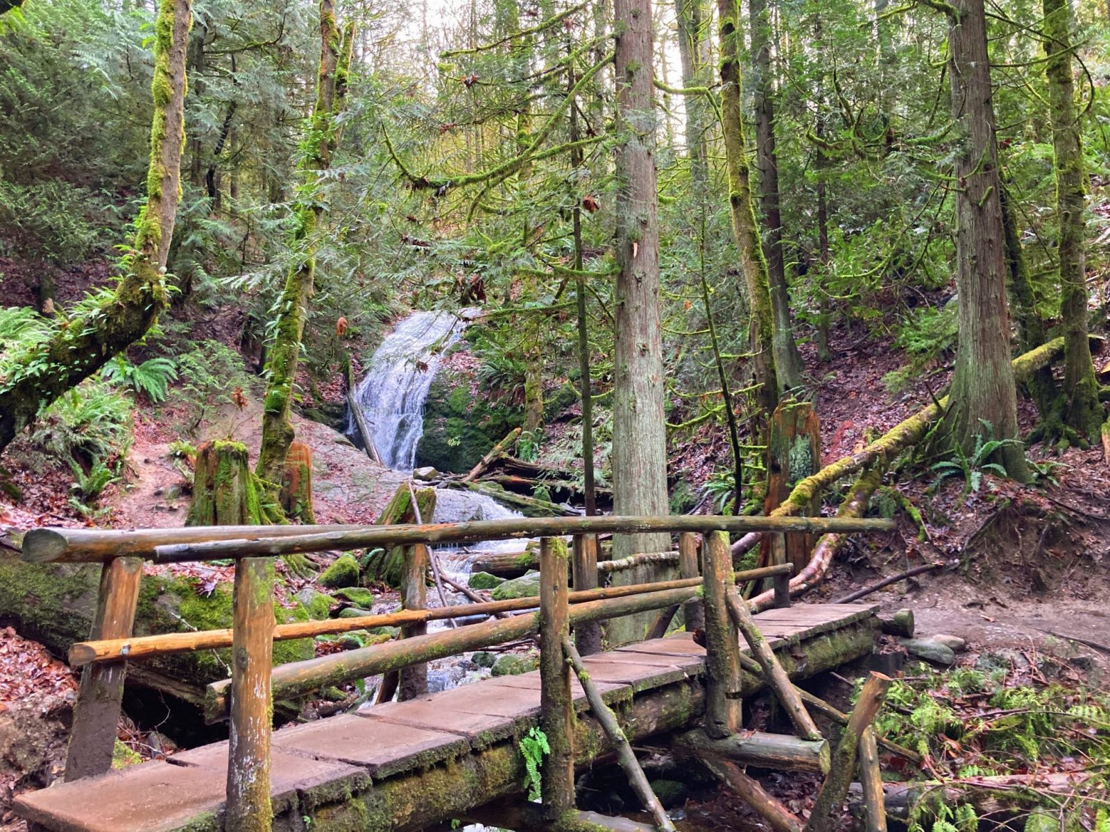
About three quarters of a mile from where you started, turn right on the Coal Creek Falls trail. Now you are on a narrower dirt trail (watch out for mud), heading down toward the creek. In about half a mile, a mile and a half from the start, you’ll arrive at a lovely log bridge over the creek with Coal Creek Falls just ahead of you.
To complete the loop, continue across the bridge and climb up a bit on the Coal Creek Falls Trail for a third of a mile to a junction with the Quarry Trail. Now heading downhill, in half a mile you will briefly join the Indian Trail (turn right) and then you’re back to the Red Town Trail. Turn right again.
Back on a wide gravel trail, you’ll cross Coal Creek again. At this point you’re just under a mile from your starting point. Follow the Red Town Trail back down to the parking lot for a total loop of three miles.
Two Mile Coal Creek Falls Hike from Sky Country Trailhead
For a two mile out and back hike to Coal Creek Falls from the Sky Country Trailhead, start on the Nike Horse Trail for a quarter mile. When it ends on the Cave Hole Trail, go right. In another quarter mile, you’ll come to the Coal Creek Falls trail where you go left. In half a mile, you’ll come to Coal Creek Falls the same way you would if you started at the Red Town Trailhead.
Once you reach the falls, you can turn around here for a two mile hike. Looking to go further? Check out the six mile loop from the same trailhead below.
Six Mile Loop including Coal Creek Falls from Sky Country Trailhead
Cougar Mountain has lots of trails and junctions, and while they are well signed, it’s imperative that you have a map so you know which trail you want to take at each of the many junctions! You can also easily make up your own loop from the maps as well. This loop is a figure 8, so you could stop in the middle if you were done and shortcut back to the car.
On with my favorite loop! As described it’s approximately 6 miles and 500 feet of elevation gain (there are some hills and some flat sections). Here are the steps (like I said, there are lots and lots of trails connecting here! Refer to the map, many of these trail segments are short):
- From the parking lot at the Sky Country Trailhead, take the Nike Horse Trail. If you are facing the blue sign that says “Sky Country Trailhead” it is NOT the trail there. Turn 90 degrees to the right, or to your 3 o’clock, and you’ll see another trail on that side of the parking lot. This is the Nike Horse Trail. Take it.
- The Nike Horse Trail dead ends at the Cave Hole Trail. Turn right. This goes down a fairly steep hill (it seemed like the steepest part of the loop) for a short distance.
- Find the Coal Creek Falls Trail on the left. It’s a sharp left turn. This will take you down towards the creek and in less than a mile cross a bridge where you’ll see the beautiful Coal Creek Falls (the falls is most impressive in winter and spring). Continue on back uphill now until the trail ends at the Quarry Trail. Turn left here.
- At the next intersection with the Shy Bear Trail and the Fred’s Railroad Trail, go left on the Fred’s Railroad Trail. Stay on it (ignoring the By Pass Trail on the left just before the road unless you want to shorten the loop), crossing Clay Pit Road. At the crossing of Clay Pit Road the trail changes its name to the Klondike Swamp Trail (you’ll see a sign across the road).
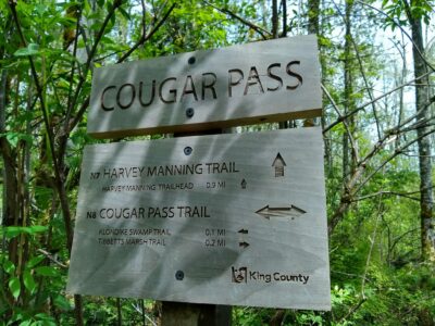
- Continue on the Klondike Swamp trail until you see the Cougar Pass Trail on the right. Take it. Very shortly you will see a big sign for Cougar Pass, but it really doesn’t feel like a pass!
- At the Cougar Pass sign, you’ll go sort of straight and sort of left (not right) and will be on the Harvey Manning Trail. Stick with that. Follow the Harvey Manning Trail almost to the Harvey Manning Trailhead (which you can detour to if you want to see a view or need an outhouse). Just before the trailhead there’s another junction. Here go left on the Lost Beagle Trail.
- The Lost Beagle Trail climbs a bit and goes back down to the Klondike Swamp Trail, where you turn left.
- When the Klondike Swamp Road cross Clay Pit Road, go right and follow Clay Pit Road back down to the parking lot.
- If this seems like a lot of directions and trails to keep track of (too many for me!), print out the map above at home and highlight the route (or a different route, you can make up your own!). I know I already said this but really, truly you need a map here, unless you have a photographic memory or can keep lots of directions in your head, unlike me!


Related posts:


