17 Fun Stops on the Vancouver to Whistler Drive
Last Updated on January 30, 2024
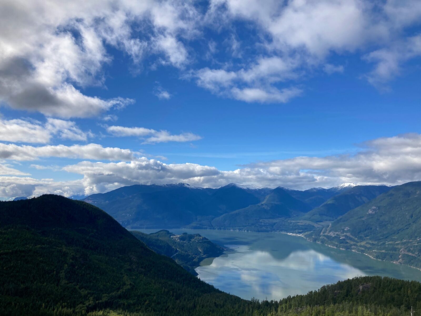
The Vancouver to Whistler drive, known to locals as the Sea to Sky Highway, takes drivers from the coast of the lower mainland of British Columbia up to the towering mountains of Whistler in just 120 km (75 miles). This spectacular stretch of road is only a couple hours of driving time, but you want to take your time so you don’t miss any of this amazing scenery! From towering mountains with year round snow caps, to the fjords of the Salish Sea, you’ll find beaches, museums, hikes and photography opportunities literally around every corner.
If you don’t have access to a car, there are charter buses you can take from downtown Vancouver or the Vancouver Airport to get you to Whistler. You’ll still get the amazing views! This article focuses on a road trip from Vancouver to Whistler and all the amazing stops you can make along the way.
You can also use this drive as a jumping off point for driving from Whistler to Jasper or Vancouver to Banff, or both!
The Vancouver to Whistler drive on the Sea to Sky Highway takes you through the homeland of the Squamish, Musqueam, Tsleil-Waututh, Lil’wat, and St’át’imc First Nations.
Related: Best things to do for three days in Vancouver
- How long is the Vancouver to Whistler drive?
- What are the road conditions like?
- When is the best time of year to drive the Sea to Sky Highway?
- Lighthouse Park
- Horseshoe Bay
- Porteau Cove
- Britannia Mine Museum
- Murrin Provincial Park
- Shannon Falls
- Sea to Sky Gondola
- Stawamus Chief Provincial Park
- Town of Squamish
- Eagle Run Viewing Shelter
- Alice Lake Provincial Park
- Brohm Lake
- Tantalus Lookout
- Brandywine Falls
- Whistler Train Wreck
- Virgin River Filming Locations
- Popular hikes on the Sea to Sky Highway
- Electric Vehicle Charging Locations
How long does the Vancouver to Whistler drive take?
Driving from downtown Vancouver to Whistler is 120 kilometers and 136 kilometers from Vancouver International Airport to Whistler. Driving time without stops is about 2 hours.
Plan on spending the whole day doing the Vancouver to Whistler drive because it’s so beautiful and there’s so much to do and see! If your schedule allows, I recommend spending two days making the trip with an overnight in Squamish, especially if it’s clear weather and you can see all the epic views!
What are the road conditions like from Vancouver to Whistler?

Photo Credit: Destination British Columbia
The Sea to Sky Highway from Vancouver to Whistler is a major highway that is well maintained. Some parts of the highway are four lane divided highway and some sections are two lane highway.
The road is very windy and steep in places. In wet weather and winter storms driving can become slow and difficult. Be sure to check Drive BC for the latest conditions for your road trip, especially in winter.
When is the best time of year for the Vancouver to Whistler drive?
The road is open and busy all year. In winter, winter driving conditions may exist (check before you drive) that can make the drive slow and treacherous. Winter is very busy with plenty of traffic going back and forth from Vancouver to Whistler.
Summer is also extremely busy with the large amount of outdoor activities available in Squamish, Whistler the interior of BC beyond Whistler, and everywhere along the highway.
Spring and Fall are likely your best bet to avoid the summer and winter crowds. The stops recommended below include the best season for each stop. Some are terrific year round, others are definitely better in one season over another.
Best stops on the Vancouver to Whistler drive
Lighthouse Park

Photo credit: Destination BC/Tom Ryan
You’re barely out of the city when you come to your first stop on the Vancouver to Whistler drive! Lighthouse Park is extremely popular with locals and parking may be full. Try to stop early in the morning in summer to find a parking spot. Getting to the lighthouse is a little less than a mile (1.5km) of mostly flat walking. There are several miles of trails in the park, featuring an impressive stand of old growth trees. This historic lighthouse was built in 1912 and served to keep ships away from dangerous rocks entering Burrard Inlet and Vancouver
- Distance from Downtown Vancouver: 20km (12 miles)
- Best season: All year
- Restrooms: Yes
Horseshoe Bay

Often overlooked on the way to the ferry, Horseshoe Bay is a lovely little village to stop at on your Vancouver to Whistler drive. If you have enough time, I recommend parking here and taking the short (20 minute) ferry to Bowen Island. On Bowen Island, you can wander around charming Snug Cove or grab a bit to eat before catching the ferry back. The ferry generally goes about once an hour, and if you walk on you don’t have to worry about the long wait lines and the expense of driving on the ferry with your car.
If you don’t have time for that, wander around the village and check out the scenery, the harbor and grab a coffee or a meal near the harbor.
- Distance from Downtown Vancouver: 21 km (13 miles)
- Best season: All year
- Restrooms: Yes, in the ferry terminal building
Porteau Cove

A beautiful beach sticking out into the water at the site of a former ferry dock, there’s lots of action at Porteau Cove. An underwater park designed for divers is just off the north side of the parking area and you have a great chance of seeing divers getting in and out of the water.
This is also a wonderful beach for tidepooling at low tide, with it’s long beach and many rocks. There is a beautiful campground here. The picnic tables as well as the campground make for an amazing place to watch a sunset on a clear day.
The views from the parking area are worth a stop even if you don’t have time to linger.
- Distance from Downtown Vancouver: 44 km (27 miles)
- Best season: Any sunny day, especially at sunset
- Restrooms: Yes
Britannia Mine Museum

The Britannia Mine Museum is a National Historic Site offering the unique opportunity for an action packed underground tour where you get to experience what a mine was like at the turn of the last century and over much of the 20th century. You can also try gold panning while you’re here too.
- Distance from Downtown Vancouver: 52 km (32 miles)
- Best season: All year, though hours vary seasonally. Mostly an indoor experience (good for a rainy day)
- Restrooms: Yes (also a restaurant)
Murrin Provincial Park
Browning Lake is located in the park and right next to the highway. It’s a small lake, perfect for swimming on warm days or having a picnic on your Vancouver to Whistler drive. There are plenty of picnic tables and a mellow hiking trail around the small lake. The park also has lots of rock climbing locations.
- Distance from Downtown Vancouver: 55 km (34 miles)
- Best season: Late summer and early fall on hot days perfect for a swim in a refreshing lake
- Restrooms: Pit toilets only
Shannon Falls

Shannon Falls is a stunning 330 meter (1100 foot) waterfall crashing down the rock face into the evergreen forest. It’s visually stunning and its roaring and crashing can be heard almost from the parking lot. You can also hear and see it from the Sea to Sky Gondola although your view isn’t as good as the view from the trail below.
It is one of the highest waterfalls in British Columbia and one of the easiest to get to.
From the parking area, it’s about a third of a mile to the waterfall viewpoint. There is a wide, graveled, wheelchair accessible trail from the parking area to the viewpoint. It does go uphill some on the way and downhill on the way back. There is also a dirt packed trail to the same viewpoint that follows the river through the thicker forest.
- Distance from Downtown Vancouver: 59 km (37 miles)
- Best season: All year – the waterfall is especially epic in winter and spring, but it has plenty of water flow to be beautiful all year
- Restrooms: Yes. Pit toilets and flushing toilets near the parking area. The flushing toilets are closed in winter.
Sea to Sky Gondola

The Sea to Sky Gondola takes you up and over a couple of rock faces over 3000 vertical feet to a spectacular viewpoint at the top. Though expensive, on a clear day this is well worth the money and a great way to see the incredible view without hiking.
You can also hike to the top (see hiking section below) if you prefer to get there that way! Once you arrive at the top there are a number of hiking trails ranging from short and mostly flat to more strenuous that can take you to even more views.
Make sure to walk across the suspension bridge if you’re ok with suspension bridges for a great photo opportunity and even more views.
If you’re not planning to hike, you can still spend some time at the top enjoying some food in the restaurant (indoor and outdoor seating) so you have plenty of opportunity to soak up the view.
There is also a food court in the area around the top as well as picnic tables, some of which are covered.
- Distance from Downtown Vancouver: 60 km (37 miles)
- Best season: Summer – or any clear day to see the view year round!
- Restrooms: Yes, at the base and at the top (also food available at both the base and top)
Stawamus Chief Provincial Park

Stawamus Chief Provincial Park adjoins the Sea to Sky Gondola and Shannon Falls, but has it’s own parking area. You can walk here from the Sea to Sky Gondola parking area or the Shannon Falls parking area if you don’t to deal with finding parking multiple times.
The park is home to one of the area’s most beloved hiking trails, Stawamus Chief. This steep hike (6 km/3.5 miles round trip with 650 m (2000 feet) of elevation gain) takes you to an incredible view of Howe Sound, similar to the views on the Sea to Sky Gondola, but with views of the town of Squamish as well. There are several different places to see views from the trail, so you can go a shorter distance if you prefer.
Stawamus Chief is also extremely popular for rock climbing. Keep your eyes out for climbers on the vertical face of the mountain.
- Distance from Downtown Vancouver: 60 km (37 miles)
- Best season: Summer
- Restrooms: Pit toilets only
Visit the town of Squamish

Squamish is a delightful outdoors oriented town that makes a wonderful stop on your Vancouver to Whistler drive. If you have the time, I recommend overnighting here so you have time for even more stops! At least stop in to grab lunch or Happy Hour at Howe Sound Brewing and give yourself some time to walk around town.
There’s a flat trail that goes from town out toward the docks that gets you some beautiful views of the mountains surrounding town and the head of Howe Sound. Squamish is also a good place if you just need a quick stop for gas, EV charging and a quick bite before getting back on the road.
Squamish is an outdoorsy town, focused on skiing in winter, rock climbing and rafting in summer and hiking and biking all the time.
- Distance from Downtown Vancouver: 64 km (40 miles)
- Best season: All year
- Restrooms: Plenty of restrooms and restaurants as well as gas and other necessities
Eagle Run Viewing Shelter

Fans of the Netflix series Virgin River will recognize this area and shots of the Squamish River from the show as scenes were filmed near here. Even if you don’t know anything about that, this stretch of river is absolutely beautiful. Eagle Run is named because bald eagles congregate here in the winter, making it a mandatory stop during that time of year. Even if it’s not the ideal season for eagles, you may well still spot them in the trees across the river. Late summer and early fall bring salmon runs through so you might see salmon below you in the river too. There is a short graveled path above the river with interpretive signs about eagles and the history of the river and its people.
It’s very close to Squamish, though technically in Brackendale, just a few kilometers north of Squamish. You can get there on a backroad and then join the highway north of town.
- Distance from Downtown Vancouver: 69 km (43 miles)
- Best season: Winter (for seeing the most eagles, it’s beautiful year round)
- Restrooms: Port-a-potties
Alice Lake Provincial Park
Alice Lake is your best stop on the Vancouver to Whistler drive for paddling a kayak or paddleboard if you don’t have your own you are bringing with you. There are rental kayaks, canoes and paddleboards available here during the summer. This is also a great place for swimming, the water gets fairly warm and there are a couple of roped off swimming areas. There are also many miles of hiking trails to several other lakes.
- Distance from Downtown Vancouver: 75 km (47 miles)
- Best season: Summer (for swimming and rental canoes, kayaks and stand up paddleboards)
- Restrooms: Pit toilets and flushing toilets
Brohm Lake
Brohm Lake is probably your best option for swimming along the Sea to Sky Highway – there’s even a rope swing and big rocks to jump off! This is a very popular area with locals and visitors so parking may be a challenge at times. This is a great place to get your kayak, paddleboard or canoe in the water too.
- Distance from Downtown Vancouver: 79 km (49 miles)
- Best season: Summer
- Restrooms: Pit toilets only
Tantalus Lookout
Tantalus Lookout makes for a safe place to pull over and take in the epic mountain views before you get into trouble paying attention to the scenery instead of driving! The best way to do this is actually driving south from Whistler to Squamish or Vancouver since the lookout is on that side of the road. There is a small pullout on the northbound side as well.
Check out the views in all directions of mountains upon mountains and the valleys below.
- Distance from Downtown Vancouver: 81 km (50 miles)
- Best season: Summer or any clear day to see the view year round
- Restrooms: None
Brandywine Falls

Brandywine Falls is a beautiful 70 meter (230 feet) waterfall that dives over a cliff into a shallow pool of water below. A short and mellow walk takes you 1 km (just over half a mile) to this beauty. There is an active train track crossing on the way, make sure to look for trains and cross directly over. Do not walk or take pictures on the train tracks!
- Distance from Downtown Vancouver: 105 km (65 miles)
- Best season: Winter and spring for the most epic water flow, but there is some water in the falls year round
- Restrooms: Pit toilets only
Whistler Train Wreck

Photo Credit: Jay Flaming
Just before you arrive in Whistler, make sure to stop at the one of a kind so-called train wreck, a collection of old railroad box cars that are randomly strewn around an evergreen forest. A photographer’s delight, with their bright graffiti colors lying in the middle of the forest, this is a fun stop for kids too. You do have to walk to get here, it’s about a 2km round trip walk (1.25 miles) with very little elevation gain. There is a short steep section right by the suspension bridge. You will cross a pedestrian suspension bridge over the river to get there. Watch out for tree roots along the trail.
- Distance from Downtown Vancouver: 112 km (65 miles)
- Best season: Spring through Fall, but open all year
- Restrooms: None
Check out Virgin River Filming Locations

Fans of the Netflix show Virgin River will be thrilled to hear that many scenes from the show were filmed along the Vancouver to Whistler Drive. A few places to stop to step into your own imaginary Virgin River include:
- West Vancouver – a number of scenes were filmed in the shopping area of West Vancouver
- Eagle Run and Watershed Grill – the Watershed Grill served as the outside shot for Jack’s Bar in the series, and is right next to Eagle Run. Many episodes have shots of the river in this area, it will look familiar!
- Shannon Falls – Most of the scenes showing Mel running have a glorious waterfall in the background and that waterfall is Shannon Falls! You don’t even have to go for a run to see it, it’s just a short walk from the parking area.
- Bowen Island – if you have the time to spend a day or a few hours on Bowen Island, you’ll see many familiar buildings and streets in the tiny village of Snug Cove, where the ferry docks from Horseshoe Bay
Take a Hike

Photo Credit: Destination BC/Ben Girardi
There are plenty of opportunities for hikers to get out and stretch their legs on the Vancouver to Whistler drive, from old growth forest at the coast to epic mountain views. Hiking season along the Sea to Sky corridor is generally July through October. The high country definitely has snow through June, though lower elevation hikes are good options starting in May.
A few crowd popular options include:
- Lighthouse Park – This park surrounding the Point Atkinson Lighthouse has about 10 km (about 6 miles) of trails that go through gorgeous old growth forests with views of the water. There is only a small amount of elevation gain and loss and the trails are very well maintained. Good year round option.
- Tunnel Bluffs – A gorgeous viewpoint starting from a pullout on the Sea to Sky Highway near Britannia Beach, this hike switchbacks steeply uphill at first and then mellows out traversing an old logging road to a spectacular viewpoint of Howe Sound. Save this one for a clear day so you can see the view. At 11 km round trip with 500 meters of elevation gain (about 7 miles and 1500 feet elevation gain), this hike isn’t easy or fast, but it’s wonderful if you have the time.
- Stawamus Chief – One of the area’s most popular hikes, don’t expect solitude here, but you can expect an incredible view! This is a good alternative to the gondola area if you want to hike instead. There are several viewpoints but plan on a 6 km round trip hike with 650 m of elevation gain (a bit over 3.5 miles with 2000 feet of elevation gain. Some portions of this hike are VERY steep so this is another one that’s not quick, but totally worth it.
- Sea to Sky Summit – If you want to get to the top of the Sea to Sky Gondola without paying, you can hike there instead! This is a tough climb, but leads to a great reward (that you could also gondola to!). The hike is 13 km round trip with 920 meters of elevation gain (8 miles with 3000 feet of elevation gain).
- Half Note Loop from the Whistler PEAK 2 PEAK – if you’re there from mid or late July through mid September, do not miss this epic hike! Don’t underestimate this 4 mile hike with 800 feet of elevation gain as it also has nearly 2000 feet of downhill which is very challenging.
Electric Vehicle Charging on the Sea to Sky Highway from Vancouver to Whistler
I always recommend using the Plugshare app for the most up to date information about charging locations and any service outages. There is fast charging available in Vancouver, Squamish and Whistler, which should be enough for most EVs to make the trip. There is also a BC Hydro fast charger in Horseshoe Bay.
You’ll need an account with BC Hydro to use their chargers (which are excellent in my experience). BC Hydro recently announced plans to triple the number of public chargers in BC over the next few years, so access to EV charging is likely to get even better.


